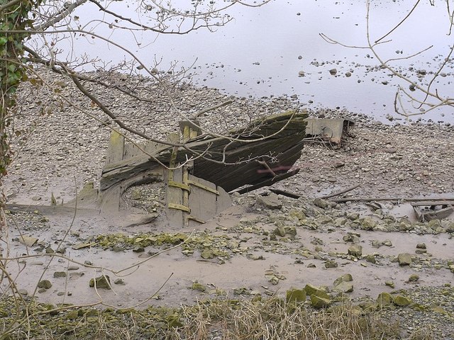
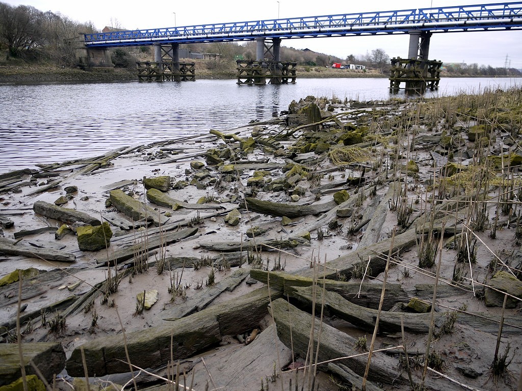
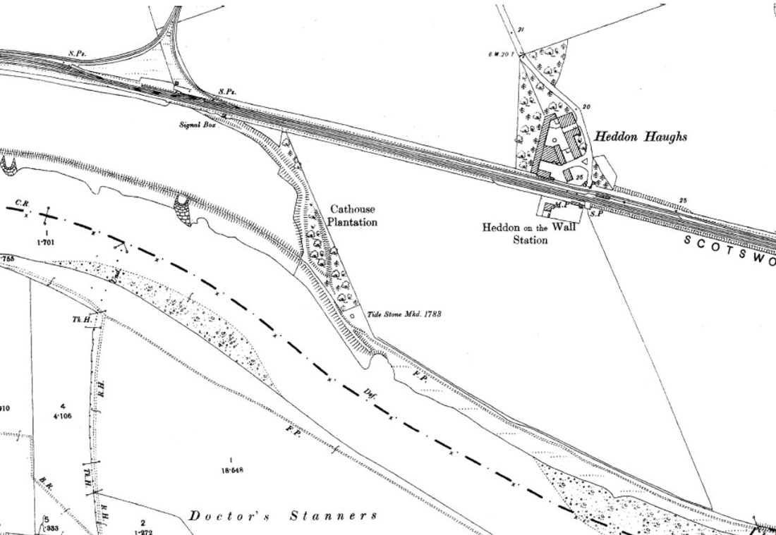
As part of my research for the Puffing Billy Festival this summer I decided to see what I could find out about the eastern end of the Wylam Waggonway. This was built to carry coal from Wylam Colliery to coal staiths on the River Tyne at Lemington.
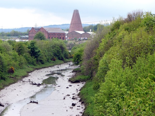
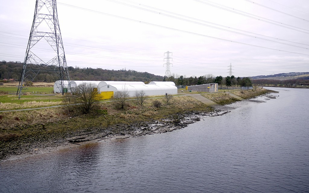
4 Comments
A talk by Robert Forsythe on Monday 22 April 2013. Robert made reference to several sources in his talk:
The furthest navigable point upriver on the River Tyne was at Stella near Blaydon. There were staiths here where coal was loaded onto flat-bottomed keels for transport down river to colliers. An early wooden waggonway (1600s) approached the staiths from the west along what is now the course of the modern B6317 road via Hedgefield and Crookhill south of old Ryton village. The Runhead Inn marks the top of the incline.
A northern branch of this waggonway served pits just east of Prudhoe and may have crossed the Stanley Burn on the old bridge now in woodland south of the main road. Chris Richardson made contact following a mistake I made regarding the Snowdon family in a previous article on the blog about Heddon in 1901 using the Census records. I have now corrected that error. He has kindly sent the following photos, one of a Snowdon family group, and two atmospheric photos of the locality for which I am extremely grateful. Left to right Back row: Nicholas, Margaret, William, John, Jane Ann, Ellen Middle Row: Isabella, John (Father) Margaret (Mother) Evelyn (Baby), Anthony, Esther Front Row: Annie Lydia, Thomas (with boat), Samuel Following on from my previous blog about the remains of the wherries at Newburn Bridge, I decided to investigate this wreck which is further upriver, although on the same (south) bank of the River Tyne. At low tide, it is clearly visible from the path between the river and railway line, on the stretch between Ryton Golf Club and Ryton Ferry House. The stern section with propeller shaft and rudder can still be seen, but much of the vessel is buried in mud.
The existing woodwork above ground level has had photographic targets attached, showing that it was probably surveyed some time previously. The only publication referring to it I could find online was a short article in the free advertising newspaper, Tyne Valley Express, in 2011. In 2009, an archaeological survey was conducted in advance of a proposal by the Tyne Rowing Club who wanted to build a new flight of steps down to the waters edge on the south (Gateshead) bank of the River Tyne, just west of Newburn Bridge. The Historic Environment Record noted the survival of a spread of old boat timbers, representing the remains of a possible five vessels at this point of the river. The boats were of a type of river barge known as a wherry, a common sight on the river until the 1960s. The wherries at Ryton were beached at this location between the 1940s and the 1960s by the Port of Tyne Authority when they were no longer in service, to remove them from the navigation channels, further downstream. Later photographs (from SINE, Newcastle Libraries Collection & Beamish) show how the wrecks have deteriorated over time (click photos for link).
This article was written with the kind help and encouragement of Ted Burt, John Gillott & David Potts of the Heddon on the Wall Local History Society. Without the assistance of these, and the authors referenced below, who know about railways, I would still be wondering. The Wylam wagon-way was built around 1748 to a five foot gauge, and was used to transport coal from Wylam to Lemington where coal staiths stood to load shallow-bottomed keel boats for shipment down the River Tyne. The closure of the Wylam Colliery in 1868 resulted in the wagon-way having very little use, until the Scotswood to Wylam railway line opened in 1875-76, following much of the wagon-way route. Heddon-on-the-Wall Railway Station was added 5 years later in 1881. The platforms were staggered each side of a level crossing, that to the east, on the north side of the double track, used by trains traveling east towards Newcastle. This 'Northern' line also included a spur which ran into the yard of the Margaret Pit and Heddon Brick Works. This so-called 'triangular junction' can be seen in the map below, west of Heddon Station. Only the east side of this junction is retained today in a strip of woodland and existing field boundaries. The west side has been ploughed out within an arable field. The road that runs steeply downhill south of Heddon village is named Station Road. It ends at Heddon Haughs Farm on the line of the wagon-way. Large scale maps show that the colliery line ran parallel to the main line, passing directly behind the Newcastle platform. Heddon-on-the-Wall Railway station, situated near Heddon Haughs Farm, was closed in 1958, and finally demolished in 1959. The current Heddon Haughs farmhouse, south of the wagon-way, incorporates the original Station-Master's house. The 'Northern' railway line was closed in 1966 and the tracks were removed in 1972. This part of the route was then turned into a public bridleway and cycle track. Since I first came across it, I was puzzled by the branch line (shown below) that bends south away from the wagon-way close to the east side of the 'triangular junction', running through Cathouse Plantation. It is clearly a disused railway line or wagon-way, built-up on colliery waste. In one place, the farmer has cut through the bank to provide access between the neighboring fields. The line appears to have terminated on the bank of the River Tyne, just west of the Tide Stone.
None of the old OS maps shows the existence of a track along this route, making it likely to have been in only temporary use. I wondered at first if it had provided a way of disposing of pit waste form Heddon Colliery, perhaps by dumping it in the river.
Dr Tony Barrow
The history of our region and the sea was covered from the mesolithic house at Howick, through Roman times (Arbeia), medieval monasteries, the industrial revolution, to World War 2 and beyond; taking in the long span of coastline from Berwick to Yorkshire. There was a little bit of everything, ranging from economics, social history and naval history with just enough detail on some topics leaving you wanting to know yet more. The talk was well attended and all there will have left with their own highlights. These are just some of mine. Under, 'ports and harbours', we were introduced to the medieval port of Warkworth, painted by Turner in 1799, Seaton Sluice, almost unchanged from its days as a thriving coal port in the 18th century, and an aerial view of the lower River Tyne, with developments spanning 1000 years.
|
AuthorAndy Curtis Archives
May 2024
Categories
All
|
- Home
- Calendar
- Introduction
- Where are we?
- History Map
- Timeline
-
Heddon's History
- Prehistory
- Hadrian's Wall >
-
Six townships
>
-
1 Heddon township
>
- Heddon in the Middle Ages
- Common Land
- Middle Marches
- Tithe Award
- St Andrew's Church >
- Village property
- Heddon Hall >
- Heddon Banks Farm
- Frenchman's Row
- Methodist Church >
- Men's Institute
- Women's Institute
- Welfare Field
- Knott Memorial Hall
- Memorial Park
- Schools
- River Tyne
- Coal Mining
- Quarrying
- Water Supplies
- Transport
- Waggonway & Railway
- Occupations from 1800
- Miscellaneous
- 2 West Heddon township
- 3 East Heddon township
- 4 Houghton & Close House township >
- 5 Eachwick township
- 6 Whitchester township
-
1 Heddon township
>
- Rudchester
- People
- Old Photos
-
Old News
- Community News
- Letter from the Emigrant Clergy of Frenchman's Row (1802)
- Alleged Brutal Murder at Heddon-on-the-Wall (1876)
- Sad boat accident at Ryton (1877)
- Coronation tree (1902)
- 65 Years on a Ferry Boat (1929)
- Come claim your kiss at Heddon (1953)
- The Swan (1972)
- Heddon WI (1987)
- Church House (1966)
- Happy return (1993)
- Hexham Courant (1997)
- Butterfly Garden (1999)
- Foot & Mouth (2001)
- Remembrance Day (1996)
- Remembrance Day (2016)
- RAF at Ouston (2007)
- Close House Golf Course (2009)
- Heddon pupils celebrate British heritage (2011)
- Roman Wall Forge (2011)
- Diamond Jubilee (2012)
- Auction of Bronze Statue, Close House (2012)
- Heddon WI (2012)
- Puffing Billy Festival (2013)
- Heddon Village Show (2014)
- View of the North (2014)
- The Wall at Heddon (2014)
- Heddon Village Show (2015)
- War veterans singing send-off (September 2015)
- Anglo-Saxon history (2014)
- Heddon WI at 100 (2017)
- Hadrian's Wall discovery (2019)
- Tulip Mews (2020)
- Mike Furlonger
- Hadrian's Wall 1900 Festival
- Memories
-
Other documents
- Mackenzie (1825)
- Bates (1886) >
- History, Topography & Directory of Northumberland (Bulmer's) - 1886
- History of Northumberland (1930)
- Collingwood Bruce (1853)
- Whellan (1855)
- Post Office Directory (1879)
- Prominent people in Heddon
- Place names
- Ad Murum
- Archived documents
- Thomas Bewick's History of British Birds (1826)
- Census data 1801-1991
- Historical Records 1888-1890
- Knott Sale of Village Property (1924)
- Extracts from Parish Council Records
- Local colliery records
- Blackburn (1938)
- Clark (c.1963)
- History of Church (1968)
- Boundary Commission Report 1984
- Village Atlas 2022
- Walks
- Blog
- Contact us
- Links
- What's new
- Site search
- Past & Present
- Photo of the Month
- Place Name Studies
- Heddon from Above